PLACES OF TOURIST ATTRACTIONS IN BANGLADESH
Tourist site of Sundarbans
SUNDARBANS - HOME OF THE ROYAL BENGAL TIGER & MANGROVE FOREST
 Located near Khulna about 320 Km. west of Dhaka. Here in the south, spread over an area of about 6000 sq. km. of deltaic swamps along the coastal belt of Khulna is the biggest mangrove forest, Sundarbans (beautiful forest)- the home of the Royal Bengal Tiger. Its dense rain forests are criss crossed by a network of rivers and creeks. One finds here tides flowing in two directions in the same creek and often tigers swimming across a river or huge crocodiles basking in the sun. Other wildlife in this region are cheetahs, spotted dears, moneys, pythons, wild bears and hyenas. The forest is accessible by river from Khulna and Mongla. There are rest houses for the visitors to stay and enjoy the unspoiled nature with all its charm and majesty. Spending some times inside the forest can be a rara treat for the lovers of nature. Guided Tours in Sundarbans TRAVEL BANGLADESH (TRAVELBD) arranges guided package tours for groups of 2 to 8 and above from Dhaka to Sundarbans.
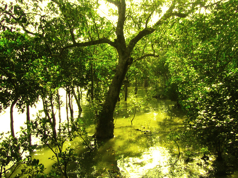

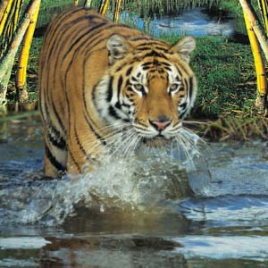
 The Sundarbans is intersected by a complex network of tidal waterways, mudflats and small islands of salt-tolerant mangrove forests. The interconnected network of waterways makes almost every corner of the forest accessible by boat. The area is known for the eponymous Royal Bengal Tiger (Panthera tigris tigris), as well as numerous fauna including species of birds, spotted deer, crocodiles and snakes. The fertile soils of the delta have been subject to intensive human use for centuries, and the ecoregion has been mostly converted to intensive agriculture, with few enclaves of forest remaining. The remaining forests, pain together with the Sundarbans mangroves, are important habitat for the endangered tiger. Additionally, the Sundarbans serves a crucial function as a protective barrier for the millions of inhabitants in and around Khulna and Monglaagainst the floods that result from the cyclones. Sundarbans have also been enlisted amongst the finalist in the New7Wonders of Nature.
History
The history of the area can be traced back to 200–300 AD. A ruin of a city built by Chand Sadagar has been found in the Baghmara Forest Block. During the Mughal period, the Mughal Kings leased the forests of the Sundarbans to residents. Many criminals took refuge in the Sundarbans from the advancing armies of Emperor Akbar. Many have been knwon to be attacked by Tigers[3] Many of the buildings which were built by them later fell to hands of Portuguese pirates, salt smugglers and dacoits in the 17th century. Evidence of the fact can be traced from the ruins at Netidhopani and other places scattered all over Sundarbans.[4] The legal status of the forests underwent a series of changes, including the distinction of being the first mangrove forest in the world to be brought under scientific management.
The area was mapped first in Persian, by the Surveyor General as early as 1764 following soon after proprietary rights were confiscated from the Mughal Emperor Alamgir II by the British East India Company in 1757. As the British had no expertise or adaptation experience in mangrove forests. Systematic management of this forest tract started in the 1860s after the establishment of a Forest Department in the Province of Bengal, in British India. The management was entirely designed to extract whatever treasure's were available, but labor and lower management mostly were staffed by locals[5]
The area was mapped first in Persian, by the Surveyor General as early as 1764 following soon after proprietary rights were confiscated from the Mughal Emperor Alamgir II by the British East India Company in 1757. As the British had no expertise or adaptation experience in mangrove forests. Systematic management of this forest tract started in the 1860s after the establishment of a Forest Department in the Province of Bengal, in British India. The management was entirely designed to extract whatever treasure's were available, but labor and lower management mostly were staffed by locals[5]

The first Forest Management Division to have jurisdiction over the Sundarbans was established in 1869. In 1875 a large portion of the mangrove forests was declared as reserved forests in 1875–76 under the Forest Act, 1865 (Act VIII of 1865). The remaining portions of forests was declared as reserve forest the following year and the forest, which was so far was administered by the civil administration district, was placed under the control of the Forest Department. A Forest Division, which is the basic forest management and administration unit, was created in 1879 with the headquarter in Khulna, Bangladesh. The first management plan was written for the period 1893–98.[6][7]
Sundorbon Travel Bangladesh
Travel Bangladesh
Visit Bangladesh
Ad Film Maker
World Logiest sea batch Coxbazzar
Biggest Mangrove Forest Sundorbon
World Heritage site in Bangladesh
In 1911, it was described as a tract of waste country which had never been surveyed, nor had the census
been extended to it. It then stretched for about 165 miles (266 km) from the mouth of the Hugli to the mouth of the Meghna and was bordered inland by the three settled districts of the 24 Parganas, Khulna and Backergunje. The total area (including water) was estimated at 6,526 square miles (16,902 km2). It was a water-logged jungle, in which tigers and other wild beasts abounded. Attempts at reclamation had not been very successful. The characteristic tree was the sundari (Heritiera littoralis), from which the name of the tract had probably been derived. It yields a hard wood, used for building, and for making boats, furniture, etc. The Sundarbans were everywhere intersected by river channels and creeks, some of which afforded water communication through out the Bengal region both for steamers and for native boats.

Climate change impact
The physical development processes along the coast are influenced by a multitude of factors, comprising wave motions, micro and macro-tidal cycles and long shore currents typical to the coastal tract. The shore currents vary greatly along with the monsoon. These are also affected by cyclonic action. Erosion and accretion through these forces maintains varying levels, as yet not properly measured, of physiographic change whilst the mangrove vegetation itself provides a remarkable stability to the entire system. During each monsoon season almost all the Bengal Delta is submerged, much of it for half a year. The sediment of the lower delta plain is primarily advected inland by monsoonal coastal setup and cyclonic events. One of the greatest challenges people living on the Ganges Delta may face in coming years is the threat of rising sea levels caused mostly by subsidence in the region and partly by climate change.
In many of the Bangladesh's mangrove wetlands, freshwater reaching the mangroves was considerably reduced from the 1970's due to diversion of freshwater in the upstream area by neighboring India through the use of the Farakka Dam bordering Rajshahi, Bangladesh. Also, the Bengal Basin is slowly tilting towards the east due to neo-tectonic movement, forcing greater freshwater input to the Bangladesh Sundarbans. As a result, the salinity of the Bangladesh Sundarbans is much lower than that of the Indian side. A 1990 study noted that there "is no evidence that environmental degradation in the Himalayas or a 'greenhouse' induced rise in sea level have aggravated floods in Bangladesh"; however, a 2007 report by UNESCO, "Case Studies on Climate Change and World Heritage" has stated that an anthropogenic 45-cm rise in sea level (likely by the end of the 21st century, according to the Intergovernmental Panel on Climate Change), combined with other forms of anthropogenic stress on the Sundarbans, could lead to the destruction of 75% of the Sundarbans mangroves.[12] Already, Lohachara Island and New Moore Island/South Talpatti Island have disappeared under the sea, and Ghoramara Island is half submerged.[13]
Administration
The Sundarbans area is one of the most densely populated in the world and the population is increasing, as a result half of this ecoregion's mangrove forests have been cut down to supply fuelwood and other natural resources. Despite the intense and large-scale exploitation, this still is one of the largest contiguous areas of mangroves in the world. Another threat comes from deforestation and water diversion from the rivers inland which causes far more silt to be brought to the estuary, clogging up the waterways.
The Bangladesh part of forest lies under two forest divisions, and four administrative ranges viz Chandpai (Khulna District), Sarankhola (Khulna), and Burigoalini (Satkhira District) and has sixteen forest stations. It is further divided into fifty-five compartments and nine blocks.[1] There are three wildlife sanctuaries established in 1977 under the Bangladesh Wildlife (Preservation) Order, 1973 (P.O. 23 of 1973).
Protected areas cover 15% of the Sundarbans mangroves including Sundarbans National Park and Sajnakhali Wildlife Sanctuary, Sundarbans East, Char Kukri-Mukri, Sundarbans South and Sundarbans West Wildlife Sanctuaries in Bangladesh.[11]
A new Khulna Forest Circle to preserve the forest was created in Bangladesh in 1993 and a Chief Conservator of Forests has been posted. The direct administrative head of the Division is the Divisional Forest Officer who is also based at Khulna. The Divisional Forest Officer has a number of professional, subprofessional and support staff and logistic supports for the implementation of necessary management and administrative activities. The basic unit of management is the compartment. There are 55 compartments in four Forest Ranges and these are clearly demarcated mainly by natural features such as rives, canals and creeks.
In popular culture
The Sunderbans are celebrated through numerous Bengali folk songs and dances, often centered around the folk heroes, gods and goddesses specific to the Sunderbans (like Bonbibi and Dakshin Rai) and to the Lower Gangetic Delta (like Manasa and Chand Sadagar). The Bengali folk epic Manasamangal mentions Netidhopani and has some passages set in the Sunderbans during the heroine Behula's quest to bring her husband Lakhindar back to life.
The area provides the setting for several novels by Emilio Salgari, (e.g. The Mystery of the Black Jungle). Padma Nadir Majhi was also made into a movie by Goutam Ghose. Sundarbaney Arjan Sardar, a novel by Shibshankar Mitra, and Padma Nadir Majhi, a novel by Manik Bandopadhyay, are based on the rigors of lives of villagers and fishermen in the Sunderbans region, and are woven into the Bengali psyche to an extent. Part of the plot of Salman Rushdie's Booker Prize winning novel, Midnight's Children is also set in the Sundarbans. Kunal Basu's short story "The Japanese Wife" and the subsequent film adaptation also take place here. Most of the plot of prize-winning anthropologist Amitav Ghosh's 2004 novel, The Hungry Tide, is set in the Sundarbans. The book mentions two accounts of the Banbibi story of "Dukhey's Redemption."[30]
The Sunderbans has been the subject of numerous non-fiction books, including The Man-Eating Tigers of Sundarbans by Sy Montegomery for a young audience, which was shortlisted for the Dorothy Canfield Fisher Children's Book Award. In Up The Country, Emily Eden discusses her travels through the Sunderbans.[31] Numerous documentary movies have been made about the Sunderbans, including the 2003 IMAX production Shining Bright about the Bengal Tiger. The acclaimed BBC TV series Ganges documents the lives of villagers, especially honey collectors, in the Sundarbans.
No comments:
Post a Comment